05 November 2020
New GEOINT fusion analysis tool could play role in ABMS, JADC2 systems
by Carlo Munoz
New geospatial intelligence (GEOINT) fusion analysis software, designed to leverage artificial intelligence (AI) and machine learning (ML) technologies in the management of multisourced big data streams, could find a role in a pair of the US armed forces’ premiere multidomain command-and-control initiatives.
The new GXP Fusion software developed by BAE Systems is squarely focused on helping GEOINT analysts navigate the ever-increasing stream of raw data gathered by intelligence, surveillance, and reconnaissance (ISR) satellites operating at geosynchronous orbit.
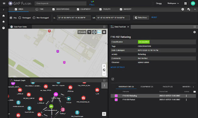
Under development for the last two and-a-half years, GXP Fusion “is really centred around how ... to solve some of our customer’s big data challenges” by enabling end users to “essentially consume and visualise” not just GEOINT data but also non-imagery based intelligence data not previously possible, said Damon Brady, senior director of product development at BAE Systems’ Advanced GEOINT Systems.
The GXP software leverages graph database capabilities and natural language processing technologies “so that we can really go and consume any information and visualise any information” that is inputted into the GXP Xplorer analysis platform, Brady said on 20 October. “That allows [end users] to unlock new insights; we can find new patterns and new relationships across multisource data [sets],” he added.
The networked graph database capability allows end users to “sort through the clutter through a set of dynamic filters ... and hone in on specific pieces of data, check the data for the specific relationships between them and then identify new things or create new linkages” to inform improved situational awareness or develop actionable intelligence, Brady said. “That graph [database] tool is really helping to quickly identify and allow the adjudication of some of these relationships” that could not be as easily visualised before, he added.
Already a Janes subscriber? Read the full article via the
Client Login
Interested in subscribing, see What we do
Share
New geospatial intelligence (GEOINT) fusion analysis software, designed to leverage artificial intel...